Oil and Gas Field Development Management

  • Express oil field development tracking and surveillance.
  • Oil field development analysis.
  • Making various reports on selected parameters and ready-made templates. Exporting using over 400 parameters.
The software is available in Windows versionInformation on the software price and purchase conditions will be provided upon request
RN-KIN - Oil and Gas Field Development Management

Benefits

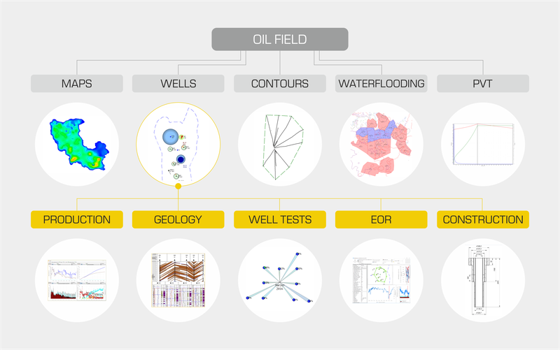
Integrated platform for oil field development design and monitoring. An integrated base of geology, production, well workover and intervention, well survey, accessible to all specialists.

Unique developments in the field of integrated design.

Development express analysis.

Geological support for well workover and intervention.
англ_бд.png

What's new

A new version annually, update every three months

Version 2024

Version 2024

  • The funding source from table 9.1 during verification in activities is now supported;
  • “Digital assistants” have been implemented in “Well Surveys” Digital Service for the Geologist’s workstation when generating well test requests. “Digital assistants” provide control, data completeness and forecast of obviously unsuccessful surveys;
  • The original survey type in the well test request can now be replaced in “Well Surveys” Digital Service for "Well Testing Contractor Workstation" module. The individual request route for each type of well testing can now be set.
Version 2022

Version 2022

The following features have been developed:

  • Data resource RN-Research - digital process control technologies for well testing;
  • RN-Profile - for calculating production levels for fields and comprehensive assessment of promising objects;
  • Verification 9.1 - to compare objects created in the program with documentary data imported from Production Technological Information System (TIS);
  • Logistics calculation – for vehicle road data calculation taking into account road types, fill, start date and date of facility commissioning;
  • Integration of Centralized GIS - to form a desirability map from several layers of substrates.
Version 2020

Version 2020

Improvements:

  • RN-KIN interface has been brought into line with the unified style of Rosneft's corporate software.
  • RN-KIN now starts 1.5 times faster.
  • For ease of use, preconfigured sets of modules have been created for specialists in various spheres of field development.
  • Plotting of total production rates is twice as fast.
  • We added "Effectiveness analysis vs well workover" module intended for high-quality workover program planning in accordance with the obtained economic effect.
  • We implemented the ability to calculate the decline rate after well workover.
  • We upgraded energy and hydraulics calculation.
Version 2019

Version 2019

Improvements:

  • totally new interface, a modular ribbon insted of text menu items;
  • hydraulic and energy calculation improvement (in blackoil model);
  • unified repository of the surface facilities models;
  • a full cycle of the formation and approval of candidates for workover and intervention, monitoring of implementation;
  • the ability to calculate the prediction of growth and economic success.
Version 3.7.2. (2018).

Version 3.7.2. (2018).

We added new modules:

  • “Information on the EOR planned section” is the preparation of applications for the planned areas for carrying out oil recovery enhancement methods and the analysis of the methods performed.
  • “Candidates for workover and intervention” adds candidates for workover and intervention to the unified database of candidates.

Besides, there is a wide range of tools for individual adjustment of RN-KIN.

Version 3.7.1. (2017)

Version 3.7.1. (2017)

We added new modules:

  • “Well Card” is created for viewing information on wells according to a user-defined parameters.
  • “HTR Reserves Ranking” is analysis and typification of hard-to-recover reserves of the Company's hydrocarbon deposits according to their level of knowledge and profitability in order to rank the priority of investing in their development.
  • “Calculation of well permeability” is an updated calculation of well permeability based on production data.

Field Development Monitoring and Analysis

Waterflooding management

Forming waterflooding elements in manual and automatic modes, rating of waterflooding elements by the reservoir energy state and reserve recovery in order to further select candidates for well intervention and ineffective injection assessment.

Material balance

Planning of measures to maintain reservoir pressure in waterflooding elements:

  • calculation of engineering parameters by material balance method, taking into account gas factor changes under below saturation pressure conditions;
  • planning of measures to maintain reservoir pressure in waterflooding elements.

Proxy model

Single-layer two-phase hydrodynamic model. Module features:

  • automatic modeling;
  • assessment of RPM system efficiency;
  • engineering parameters forecast;
  • permeability map fixing using normal operation data;
  • isobar mapping;
  • creating maps of current densities.

Base production analysis

The module makes it possible to quckly detect deviations from the planned base production levels and promptly make decisions on their recovery.

  • Well after well factor analysis of the base fund losses.
  • Creating loss maps.
  • Decline rate calculation.

Reserves estimation and their recovery analysis

Reserves estimation

Calculation of reserves based on displacement characteristics. Detailing of original and remaining reserves, planning of further development. More than 20 displacement characteristics are built-in.

Reserves audit according to RF2005, SPE, SEC standards

  • Possibility of reserves express assessment for GKZ2001, NKZ2016, PRMS / SEC classifications.
  • Automatic creation of reserves category boundaries.
  • Volumetric method of original reserves estimation.
  • Calculating recoverable reserves using Ln(water-oil ratio) and/or Arps Decline Curves Analysis.

Substantiation, well workover and intervention design

Well workover and intervention

Full cycle of routine formation and approval for well workover and intervention: from candidate selection to monitoring the implementation.

Map generation

Creating structure maps and maps of reservoir parameters (more than 60 various maps). Generating isopach and isobar maps. Bubble maps and cumulative production maps to analyze field development.

Well survey planning

Surveys

Visualizing a wide range of surveys on the map, displaying and exporting survey results in a tabular form to analyze wells.

Well testing grids

Automated search for the minimum sufficient set of wells required to recover information about reservoir pressure on the entire production target:

  • improving the survey quality due to optimal time selection;
  • cost minimization for well testing complex;
  • minimizing oil production losses;
  • overall surveying of production target;
  • new methods of surveys.

Well testing analysis

  • Interpreting multilayer wells taking into account cross-flows.
  • Interpreting indicator cards.
  • Analytical calculation of fracture interference.

Search, storage, display and automatic interpretation of automatic well test intervals.

  • Pressure and flow rate curves.
  • Determining the influence of surrounding wells.

Profiles

Creating geological profiles and correlation schemes to establish the relationship between wells, assistance in planning well workover and intervention, visualizing the boundaries of layers and interlayers.

Development strategy design

Planned well grids and pads.

  • The wizard to create a grid of planned wells makes it possible to use 20 development systems, including systems with horizontal wells and multi-stage hydraulic fracturing.
  • Flexible configuration of well grids.
  • Informative visualization on the map.
  • Drilling rating formation.
  • Planned well grids and pads from the database or external files with the possibility of displaying additional information (planned flow rate, year etc.).

CAPEX reduction for surface facilities solutions

Surface facilities

  • Database of surface facilities models (saving engineering calculations, joint editing of the model).
  • Balance calculations for the field pipeline networks (a tool for analyzing the balance of fluids at each point of the piping system and a tool for constructing a design profile, a bank of fluid models).
  • Hydraulic calculations (PipeSim support; two new modules - our own development).
  • Energy consumption calculations for new and mature fields.
  • Raiting the commision of pads, area and other facilities based on economic performance.
  • Automatic placement of linear facilities taking into account topography and design standards.

RN-Research

  • Access for specialists from various divisions of the Company to a unified information resource;
  • Creating an application for research;
  • Up-to-date information on research results;
  • Providing specialists with research materials for testing;
  • Selection and approval of candidates for well test;
  • Analysis of performed work, workload distribution;
  • Work and assignments monitoring;
  • Plan/actual analysis of production indicators;
  • Integration with the information system for testing interpretation.

Extra features

MOR, operating practices, daily production

MOR, operating practices, daily production

Tabular display of production data and well operation modes.

Graphs

Graphs

  • Simultaneous viewing of one or a group of wells.
  • Displaying one graph in one window and several graphs in one.
  • A unified date.
  • Viewing total or average.
  • Adjusting the vertical scale of curves.
  • Displaying a graph capture.
Contours. Isolines. Marks

Contours. Isolines. Marks

  • Import from text files
  • Drawing on the map
  • Editing, adding properties
  • Calculation of isolines taking into account faults
  • Creating marks, stamps, areas
Well lists

Well lists

  • Creating well lists.
  • Import/export of well lists from external sources.
  • List operations: combining, overlap, subtraction, combining by common parts.
  • Displaying reports and tables.
Factor analysis

Factor analysis

Factor Analysis Module makes it possible to determine reservoir and well parameters and create permeability map using operating practices data after well workover and intervention.

Reserve estimation map and well testing

Reserve estimation map and well testing

  • Graphic presentation of reserve estimation maps according to the requirements and standards of the State Committee for Reserves and the Company.
  • Tabular display of testing data.
  • Testing information display on the well map.
Document archive

Document archive

Document Archive module is intended for storing and viewing non-digitized material on wells in jpg, pdf, doc, xls, txt and other formats. The files are imported with reference to the well and have a set of attributes (year, type etc.).